
UPDATED DEC. 19, 3:30 p.m.: The National Weather Service on Monday afternoon, Dec. 19, 2022 released a revised ‘Winter Storm Warning,’ effective starting 7 p.m. Monday night and continuing through Tuesday evening, Dec. 20.
Prognosticators are warning residents to expect total snow accumulations between 2 to 7 inches.
Local @SeattleWXGuy Michael Snyder released an updated video on Monday, and he warns that not all areas will receive that much snow, and to also expect things to get slushy as high temps may rise up to around 45 degrees on Christmas weekend (subscribe to his YouTube channel here):
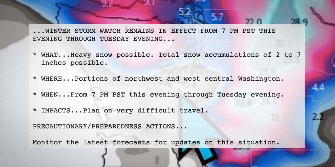
Here’s the updated Winter Storm Warning, issued at 2:31 p.m. on Monday:
…WINTER STORM WARNING IN EFFECT FROM 7 PM THIS EVENING TO 7 PM PST TUESDAY…
* WHAT…Heavy snow expected. Total snow accumulations of 2 to 8 inches.
* WHERE…Portions of northwest and west central Washington.
* WHEN…From 7 PM this evening to 7 PM PST Tuesday.
* IMPACTS…Travel could be very difficult.
* ADDITIONAL DETAILS…A transition to rain is possible across King County late tonight into Tuesday morning.
PRECAUTIONARY/PREPAREDNESS ACTIONS…
If you must travel, keep an extra flashlight, food, and water in your vehicle in case of an emergency.
For the latest road conditions in Washington state, call 5 1 1.
http://www.weather.gov/seattle
Here’s the 7-day detailed forecast:
- Monday Afternoon: Cloudy, with a high near 31. Wind chill values between 24 and 29. North wind around 8 mph.
- Monday Night: Snow likely, mainly after 4am. Cloudy, with a low around 27. North northeast wind around 8 mph. Chance of precipitation is 60%. New snow accumulation of less than a half inch possible.
- Tuesday: Snow before 4pm, then a chance of rain and snow. High near 34. Wind chill values between 24 and 29. North wind 5 to 7 mph. Chance of precipitation is 80%. New snow accumulation of 1 to 3 inches possible.
- Tuesday Night: A chance of rain and snow before 7pm, then a chance of snow. Mostly cloudy, with a low around 24. North wind around 6 mph. Chance of precipitation is 50%. New snow accumulation of less than one inch possible.
- Wednesday: Partly sunny, with a high near 30. North northeast wind 7 to 9 mph.
- Wednesday Night: A 10 percent chance of snow after 4am. Mostly cloudy, with a low around 18.
- Thursday: A 30 percent chance of snow, mainly after 10am. Mostly cloudy, with a high near 29. New snow accumulation of less than a half inch possible.
- Thursday Night: Snow likely, mainly after 10pm. Cloudy, with a low around 22.
- Friday: Rain and snow likely before 1pm, then a chance of rain. Cloudy, with a high near 38.
- Friday Night: Rain likely, mainly after 4am. Cloudy, with a low around 35.
- Saturday: Rain likely. Cloudy, with a high near 45.
- Saturday Night: Rain likely. Cloudy, with a low around 41.
- Christmas Day: Rain likely. Cloudy, with a high near 48.
The reason for the Winter Storm Watch is evident in the Satellite imagery #BCstorm #wawx #idwx #mtwx pic.twitter.com/85YIoSh3xm
— Michael Snyder (@SeattleWXGuy) December 19, 2022
Big flakes flying by this morning #wawx #snow pic.twitter.com/15S92MXnLU
— Michael Snyder (@SeattleWXGuy) December 19, 2022